09/29 - 10/06 New York and New Jersey Part II
We get brought back to the trail by Jeff’s mom. It’s about a 45 minute drive. It’s 9 by the time we are walking, which is not bad at all! It feels great walking with a light load and feeling like we’re just out for a day hike. As I always do on days hikes, I’ve packed us a deluxe lunch! Baked sweet potatoes and salad with tropical avocado!
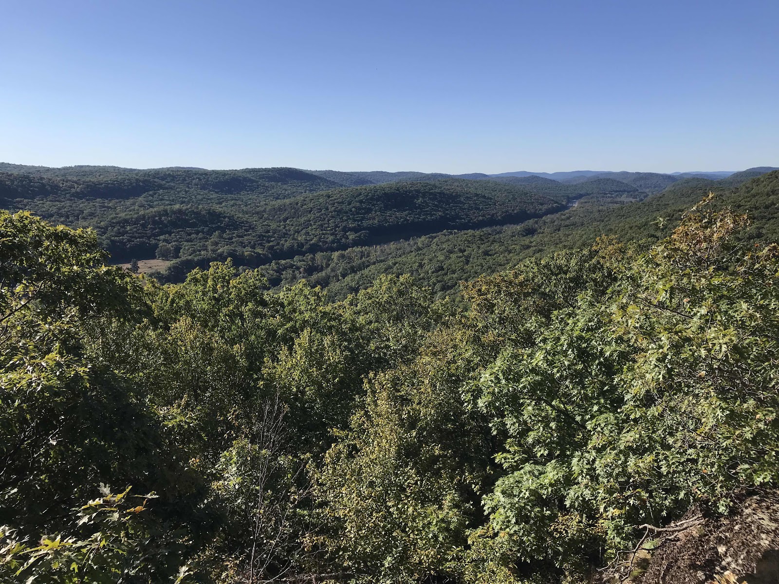
It’s been starting to look a little bit like fall, with select trees turning. There are lots of leaves on the ground, which obscures the trail and makes it a little hard to follow at times. We walk mostly in the stunted ridge top oak forest. We get a few rocky out cropping and view ledges. Mostly the walk is just an easy stroll through the forest with highlights including Franklin Falls and the Cat Rocks. We make it to Allan and Kate’s house near Warwick, New York by 5. We reach their house by just turning off the trail into the woods once we are able to make out the shape of their house. The trail really is in their backyard.
They have lived here 8 years. It’s been several years since I have visited. Jeff came once a couple years ago when I did not, so it’s been awhile for me. They have twin boys who were just babies and are now starting kindergarten! They also have a new dog since I last visited, so I get to meet Uma the dog. She is a catahoula leopard dog, a breed I’ve never heard of, but that is apparently popular in the south. She’s a real pretty dog with soft ears that are fun to pet. She’s full of energy, she’ll play fetch non stop and can catch the ball mid air!
For dinner we get Chinese take out food from the neighboring town of Greenwood Lake. It’s the same food we had the last time I was here, and we’ve been dreaming about it for hundreds of miles! It’s really good Chinese food! It is pure luxury for us tonight, we get our very own sleeping quarters! They just a bought a brand new travel trailer which is parked in the drive way and it’s ours for the night. It’s like having our own little apartment and it’s plugged into electricity, so the lights and fridge work.
Looking South down the Ramapo River Valley/Interstate 87/NY Route 17

Views west toward Mombasha High Point, above the Orange Turnpike

Nice colonies of Maitake mushrooms

Me and my XL tropical avocado. These are hard to find in California! I buy them whenever I see them. They are larger than hass avocados and are lower in fat and higher in water content.

Fitzgerald Falls

Cat Rocks

View from the Eastern Pinnacles, looking back toward Harriman State Park
Day 82
Thursday September 30th
NJ Route 94
818.4 - 833.5 = 15.1
Today we get to slack-pack. We start by just walking out the back door in the morning and into the forest. We get to go 15 miles backpack free! When we are done, Allan will pick us up on his way home from work.
We hike on ridges of rock above Greenwood Lake. We pass the highest point on the AT in New York at 1,417 feet. We also pass the NY - NJ border. The trail skirts the border between the two states, but soon we will be fully in New Jersey. We stop to enjoy the views and leftover Chinese food! Yum! I can’t think of a more deluxe trail lunch!
After the border and the view ledges we spend hours in no man’s land, just moving through the forest. We walk along the boundary of Wawayanda State park but we don’t get to see any of the park attractions, such as the lake. We almost take a side trail to a parking lot to enjoy running water and toilets, and then decide against it in favor of being done earlier.
Near the end of the day we come up to a final view ledge on Wawayanda Mountain called Pinwheels Vista. This is a popular day hike from the highway below and up what is known as the Stairway to Heaven, as the trail is made up of many stone steps. We have the easy task of going down. It’s a great view and I can see why it’s popular, we can see the valley to the west and all the way to New Jersey’s high point.
By 5 o’clock we have made it to NY Route 94 and Allan is there waiting for us. It only takes about 10-15 minutes to drive what took us all day to hike! We stop at Shop Rite on the way, it’s a very large local chain store, similar to Stop and Shop. It may be the biggest grocery store I’ve been in the whole trip! I get a few produce items for our departure tomorrow. We will be back to carrying our backpacks ourselves, all the way to the Delaware Water Gap, which is our next resupply point a few days away. For dinner we get more take out from Greenwood Lake. This time it’s Mexican food from a place called MexicanZingo! Who doesn’t love a name like that!! It’s great food too! We are so grateful for these days of rest a luxury. Getting to eat well, slackpack and have a warm soft bed to sleep in are almost as good as taking a zero!

Views of Greenwood Lake, only about a mile from Allan and Kate’s house

View ledge

Lots of view ledges in this stretch

Near Prospect Rock, the NY high point, marked by the flag

View down to Greenwood Lake and beyond to NYC skyline from Prospect Rock, NY AT high point, 1,417 feet.

Neat lines in the ridge top rock spines

NY - NJ Stateline

Cool ridge top forest of small pine trees at the state line

We spotted many maitakes today and finally I couldn’t resist and had to harvest some! My leftover Chinese takeout box made a fine carrying receptacle!

A beech tree with claw mark scratches from a bear!

A pretty little purple mushroom

Pinewheels Vista. We can see across the valley to High Point on the far ridge.

On a ledge at Pinwheels Vista, Heaven Hill Farm is directly below

View Southwest from Pinwheels Vista

This is a popular day use area and for some reason people feel compelled to pile up rocks and a lot of them!

More rock stacking on the way down the stairway to heaven.

Nice cobble path in the stairway to heaven area

Looking back up to the ridge from near the parking lot near NY Route 94, where we got picked up

Trailhead informational posters. This insect is killing all the ash trees and causing problems for the people that have large old ones in their yards. We have seen ash trees in the forest that are still doing ok.

We have seen the damage caused by these moths, especially in Connecticut, where there was an infestation earlier this year.
Day 83
Friday October 1st
Secret Shelter
833.5 - 847.1 = 13.6
We sleep deeply and peacefully inside the warm and dark camper. The night is short though, as we’re up at 5:30 and stayed up late chit chatting inside the warm and artificially lit house! Indoor lighting sure is nice when the days are short like they are now! Some nights we’re in our tent by 7 and don’t come out until 7 AM. We leave the house by 6 with Allan in his truck. He is nice enough to detour over to the trail on his way to work.
We’re walking by first light at 6:30 and it’s freezing! The thermometer on the truck dash said 40 degrees when we got out. We’re in a wet low elevation meadow area, which adds to the chill. Since we pretty much rolled out of bed and didn’t take the time to eat anything, we stop just about right away. We deploy our tent ground sheet and break out the sleeping bag for a cozy breakfast picnic.
By the time we are walking again we have some sun and a bit of warmth and it feels so much better. We walk through a big wetland on an extensive boardwalk with an impressive suspension bridge over Pochuck Creek. The bridge and the boardwalk were built and maintained by volunteers just like every thing else on the trail. There is about a mile of wooden walkways and it’s really impressive and beautiful too.
We are once again in an area with poor water options today. Many of the streams are shallow and sandy or mucky and flow past farms and houses. These types of creek have a higher chance of being contaminated with bacteria than the more pristine sources we’ve been spoiled with in the far northern reaches of the trail. There is an abandoned old house just off the trail that we are able to get water from in the morning. The building is owned by the national park service and is an official water source with a side trail and signs leading you to it.
We walk around the Wallkill National Wildlife Refuge in the afternoon. It’s a big grassy looking meadow in the bottom of a valley but it’s far from natural. We walk on earthen dams around rectangular ponds that can be drained or allowed to fill. One edge of the refuge is bordered by a busy road and we can see cars going past in the distance. The scenery is interesting and varied for us today, allowing the time to pass quickly. We expected to be trudging along today since it’s our first day in awhile carrying more than a days worth of food. We have surprisingly good energy and feel unburdened by our backpacks. Our energy levels remain a mystery to us.
In the late afternoon we reach the outskirts of the little town of Unionville. We cross several roads and a two lane highway. It’s a jungle like no mans land between the roads near town. When we reach Lott Road we take a right and head into town. It’s 0.4 miles to Wit’s End Tavern. We don’t need any food, but pub food sure sounds good! We are carrying enough food for 3-4 days, but it is all good lightweight hiker food, so we don’t mind if we continue to carry it.
We end up being super glad we stopped as the owner of the pub is super friendly and nice to us and the food is all homemade. We get veggie burgers, sweet potato fries, coleslaw, really nice salads and even some chocolate cake for dessert. We enjoy sitting in chairs inside, there is a power outlet at our table and we get to use indoor plumbing. While we are eating we hear on the news that this is the coolest temperature day since May! By the time we are ready to leave, there is a lively gathering of local regulars. It’s all older couples, making us feel like we’ve just walked into a bar full of our cruise tour bus passengers! One group offers to buy us drinks, but we politely decline and continue on our way.
It’s 5 by the time we get going again and we have less that two miles of forest walking to go to reach our shelter for the night, the secret shelter! It is a little cabin in a field about a 1/4 mile off the trail. We reach it by turning down a gravel driveway. The cabin is a real 4 sided building, not an open lean to, and it’s on private land in a big clearing and was built by a former thru hiker. It’s not an official AT shelter, but hikers are allowed to stay. There is a donkey that lives and grazes and likes to be petted. There is the hiker cabin and a few out buildings, but we don’t see the owners house. The road keeps going though, so we assume it must be somewhere down the road. We meet one other hiker who has a week and a half off work and is hiking the New Jersey section of the AT. It gets cold out quick and is dark by 8. We are all inside laying down by that point. The cabin has electrical outlets and even base board heaters, but we don’t need them, it’s nice and warm inside. We set up our air mattresses on the floor, grateful that we don’t have to deal with the tent tonight or in the morning.

Nice trailhead sign

Bridge over Pochuck Creek

Very impressive Bridge

Pochuck Creek wetlands, view from the bridge

Boardwalk through the wetlands

Some information about how it was built. We sure were glad for the boardwalks and bridges, it’s not fun to walk in the muck! It’s also not sustainable for the trail to have hikers walking in the muck or trying to find paths around it.

Nice big rhododendron leaves. We have just started seeing these in the past couple days.

A view ledge looking west to the Wallkill River wetlands and across to the high point ridge.

Abandoned house just off the trail where there is a water spigot for hikers. The building is now owned by the National Park Service. I find an unopened bottle of allergy eye drops here. My allergies stopped the day we got off the trail on Bear Mountain and haven’t returned, but I take the drops anyway. They don’t belong out here.

Wallkill National Wildlife Refuge

Wallkill National Wildlife Refuge. The trail makes two 90 degree turns around the artificial ponds of the refuge. There was an infestation of grasshoppers along the path.

Wallkill National Wildlife Refuge

Information about how they control the water in the ponds here.

View across the wetlands to the ridge we were hiking on

We cross over the Wallkill River on a bridge on Stateline Road

Views back down to the wetlands and previous ridges

Wit’s End Tavern on route 284 in Unionville, NY

A surprisingly good salad to find in a bar! Dark leafy greens and colorful veggies. This is so easy to make, why can’t more restaurants do it this way!?

Beyond burger, sweet potato fries and coleslaw. One of the better meals we’ve had on trail, everything was delicious and homemade. They even hand formed the burger patties. Also got a giant jar of Costco almond butter from the hiker box.

Boardwalks near the secret shelter

Jake the donkey at the secret shelter. He lives here and comes running out of the woods to be petted when hikers show up.

Cabin building in an open field on private land at the secret shelter. It’s owned by a former AT hiker.
Day 84
Saturday October 2nd
Mashipacong Shelter
847.1 - 859.6 = 12.5
I carried my maitake mushrooms all day yesterday and we didn’t eat them since we went out to eat in Unionville, so we have mushroom ramen noodles for breakfast along with our matcha. The mushrooms slept well in my backpack and make for tasty noodles. The maitakes shred up like the chickens of the woods and have a similar texture.
We walk through farm fields and across many rural roads in the morning as we gain elevation on our way up to High Point State Park. We stop for our second meal of the day a few hours in at the High Point Shelter. The shelter is an old stone one that was recently restored with a new roof. There is also a picnic table and one of the cleanest and most pleasant privys we have seen in awhile. We have a dark chocolate bar and coffee and oatmeal during our extra long break.
It is afternoon by the time we enter the park. We take a 0.2 side trail to reach the top of the mountain. High Point is 1,798 feet above sea level and as the name suggests, it’s the highest point in New Jersey. An impressive obelisk monument stands at the top. We are lucky to be here on the weekend, because it’s only on weekends that the you can climb the stairs to the top of the monument. It’s just a dollar to get inside, which seems to help keep crowding at bay. We climb 300 steps to the top to peer out the tiny windows. There’s great visibility today and impressive views of 3 states, New Jersey, New York and Pennsylvania. We can see the Delaware River and we can see the surrounding valleys from which we have come and the ridge that we will hike along to the Delaware Water Gap.
Back on the trail we don’t go far before taking another side trail, this time to a picnic area near Marcia Lake. We decide we don’t care about miles today. We just want to enjoy ourselves and the state park. It’s always neat walking through a tourist destination and it always feel good knowing we walked there. It’s warm and breezy today with clear skies. We take a lovely break in the grass at the picnic area and enjoy the luxury of a water spigot while we make our new protein drink for snack time which we enjoy with pretzels.
Back on the trail we pass an observation deck with views back to the obelisk, then continue walking along the ridge. I really have been enjoying the rocky ridge top vegetation of the last couple hundred miles. The trees are short up here and consist mainly of varying types of oaks and black pine. I especially like the chestnut oaks with their large serrated leaves which look exotic and tropical.
We are having such a pleasant time today. It’s days like this that make us want to keep on hiking. We have been talking a lot recently about how much longer we want to be out here. When we started the trail we didn’t really have a goal in mind. Of course it would be neat to finish, but we have been also considering going about halfway, to Harper’s Ferry and finishing the rest next year. If we stopped halfway we could go back to our winter job in Aspen for a full season. We could also avoid the discomfort of many cold winter days on the trail and also the short daylight hours that come with winter. We don’t have to decide now though, so we will keep seeing how it goes. I wish every day could be like today though!
We make one final stop in the state park in the late afternoon at the headquarters. They have bathrooms and running water. We are also able to throw out our trash and buy some extra snacks. The visitor center is in an old stone building that was built in the 30s and is quite large and impressive. While we are there we learn that the state park has a campground and lots of other trails, including one around a cedar swamp! The cedar swamp is a rare environment that we’d really like to come back and see sometime.
It’s 4 pm by the time we are leaving the visitor center and we’ve only come 7 miles. We dedicate the final few hours of day light to knocking out a few miles. We are tormented by mosquitos and practically run down the trail, adding 5.5 more miles to our day, for a total of 12.5. We make it to the Mashipacong shelter right at sunset, which is now around 6:45. The shelter is only a tenth of a mile down the trail from the Deckertown Turnpike. It’s a pretty major road with a trailhead parking lot. We were worried that the shelter might be overrun with hooligans on a Saturday night, but we are pleased to see that there are “no over night parking” signs at the trailhead. There is only one tent set up in the woods nearby when we get there and the occupant is already inside, so we never see them. We have the shelter and picnic table to ourselves to cook dinner. We have refried bean burritos with oats and dried veggies mixed in. It’s a tasty and filling dinner, especially when combined with nori wrapped power sticks and hot tea and biscuit cookies.
The shelter is on the edge of a nice big meadow surrounded by woods. We always enjoy a good open view to the sky. We decide we better get up earlier tomorrow and try to hike a little further than we have been recently. We sleep in the shelter so we can make a quick getaway in the morning.

The field where the secret shelter sits. We walked down an unmarked gravel driveway to reach this opening in the woods.

Cooking breakfast on the porch in the morning

Inside the secret shelter. It’s a fully enclosed 1 room cabin with electricity. There were no lights but there were base board heaters and a fan. The large windows let it a lot of light.

One of the roads we crossed on the way to high point near the town of Greenville, with nothing of interest to hikers that we know of.

High Point Shelter. This is an older shelter that just had it’s timbers restored and got a new roof.

View of the rocks, lichens and forest on the way up to High Point State Park, New Jersey’s highest point.

The War Memorial built in 1930 marks the high point of the state.

The CCC once had a camp here

Nearly 300 stairs to the top!

Not the most impressive observation deck!

View of Lake Steeny Kill Lake to the Southwest from the window along with the Delaware River Valley

View to the South of Marcia Lake and the the Kittatinny Mountains and ridges that we will follow for the next couple hundred miles.

View to the north, this window is rather foggy.

Looking down to the Delaware River

Another look at the impressive stairs inside the tower

Many good informational signs in the ground floor of the monument

The family that owned and donated this land for public enjoyment

The building of the monument

Signs outside with descriptions of the view in every direction. This is for the northerly view.

Looking north from the base of the monument

View west

View South

Viewing deck around the base of the monument

View to the East

Looking East

Zoomed in view to the south, where we are heading

In the grass just below the monument, view of the Delaware River valley below

High Point Veterans Memorial obelisk

Pretty sassafras leaves starting to turn color. They remind me of dinosaur feet!

Looking back at high Point from the next hill to the south

Pretty ridge top forest around high Point state park

An large decorative AT marker near the visitor center

High Point State Park map. We want to come back and see the cedar swamp!

The visitor center is located inside of a beautiful old building

Park sign

A cool old sign that’s become part of the tree

Leaving high Point State park and looking back toward Lake Rutherford from a view ledge

Another nice look at the forest today
Day 85
Sunday October 3rd
Tentsite on ridge above Buttermilk Falls
859.6 - 876.1 = 16.5
We are on rocky forested ridges all day in the oak and pine forest. We go up and down, sometimes reaching high points or bare exposed rock. It starts with Sunrise Mountain in the morning. There is a road to the top and a parking lot. At the view there is a gathering of old folks doing B.Y.O.B or bring your own breakfast! One lady has made a large batch of pumpkin muffins and she shares with us too! We enjoy them from a stone pavilion with a lovely view of the surrounding lowlands.
Up next is the Culver Fire Tower at a high point along the ridge of 1,526 feet. The tower is no longer in use and the platform at the very top is closed to the public. We are able to climb the stairs for a view just below the uppermost level.
In the afternoon we dip down off the ridge briefly as we cross NJ Route 206 at Culver’s Gap. To the South 3.5 miles is the town of Branchville. We have plenty of food, and it’s not worth it to us to hitch hike or try to arrange a taxi or Uber. The people we met on Sunrise Mountain tell us there’s a good bakery in town and how we’d love to go! But we don’t even try. Right at the road crossing there are two restaurants, Gyp’s Tavern and Mountain House Tavern. Gyp’s Tavern sees so many hikers that they have Clif bars on their menu for hikers to take to go! A meal out would be a delight and at least one of them has lake view dining. I say yay and Jeff says nay! He’s always full of excuses. Onward we go!
There are several views and open ledges in the afternoon. We pass over Rattlesnake Mountain, but thankfully see no snakes. We have actually been hiking in timber rattlesnake territory which I would not have expected! I didn’t know they were in the eastern states.
We hike until sunset, making it 16.5 miles without ever trying to push ourselves today. We hiked a full day though, so we put in the time and that’s how we go the miles. It got cloudy in the afternoon and may rain overnight and into tomorrow. We are lucky that our campsite has a nice big hemlock tree that we set up our tent under. It will be an excellent tree for shielding us from a heavy downpour.
It gets dark quick, even in the sparse ridge top forest, thanks to the clouds. We cook dinner and set up camp in the dark. We have a chorus of insects all around us. I wonder when it will get too cold for them and we will be in total silence in the dark at camp. We were happy to find a nice cluster of chicken of the woods mushrooms just before camp. I picked a bunch and we eat a delicious deluxe dinner of mushroom mashed potatoes and almond butter. It’s so good! We’ve had a lot of good food this leg! It’s nice to have the healthy items we like the most.
By 9 we are laying down inside of our tent. We are in a little clearing in the woods just off the trail. It’s just us, which we haven’t had in awhile. It’s also been awhile since we slept in our tent, more than 10 days! We’ve been sleeping in shelters, campers and houses!

Mashipacong Shelter in the morning

View from the pavilion on Sunrise Mountain 1,645 feet.

View of fog in the Delaware River Valley from Sunrise Mountain

A really nice spring that flows right out of the ground next to where Jeff is. It was full of frogs and good cold and clear water! This is the water source for Gren Anderson Shelter. Springs are our favorite sources of water.

View South from Culver fire tower

View north, back to High Point from the Culver fire tower. What a picnicking grounds below! We sure enjoyed that table!

Culver fire tower

Can you see me?

View ledge above Culver Lake

Down through the forest and off the mountain to pass through a gap

Views to Culver Lake and Branchville, NJ

Our first sighting of the invasive spotted lantern fly on Blue Mountain in New Jersey

Chicken of the woods for dinner tonight!

A rocky ledge with neat old black pines
Day 86
Monday October 4th
Mohican Outdoor Center
876.1 - 886.4 = 10.3
It’s foggy when we wake up. It rained in the night but we are nice and dry inside our tent under the hemlock tree. We try to get going quickly by not cooking breakfast. Heavy rain is predicted to begin falling around 1, and we have 10 miles to go to reach the Mohican Outdoor Center. The center is run by the AMC (Appalachian Mountain Club), the same group that ran all the huts in the White Mountains. We’ve been curious about this place for months. They have cabins and food for purchase so we will be warm, dry and well fed tonight.
All morning it remains foggy. We continue walking on the ridges like yesterday, but we can see nothing. We can imagine what it looks like, similar to yesterday. We pass by view ledges of Crater Lake and Hemlock Lake but we cannot see them. We walk along a section of ridge that was once slated to be houses and then the NPS bought it. It’s nice and flat easy walking in some places.
Around noon we dip down off the ridge to cross the paved Millbrook-Blairstown Road. For the last couple miles we have the choice between going up and over another ridge with slippery rocks in the fog or staying down low. We choose the alternate, the Rattlesnake Swamp Trail, that skirts the ridge and travels through a giant rhododendron forest instead!
We make it to the center by 12:45 and check in at the main office. We are not there much more than 5 minutes when the rain begins to absolutely pour. Since it’s still foggy there were no warning signs that it was coming. In the main building there’s a dining hall, a fire place and couches, lots of reading material and games, a small general store and gift shop, plus bathrooms with showers. The caretaker gets a fire going right away, even though it’s not really cold. We order food and lounge. About an hour and a half later Peter and Kae show up with Hoon and they are all drenched. We are very glad we got there just before the storm. They were camped several miles behind us last night.
It’s rains for hours and we all remain inside the dining hall and lounge area. We take showers and cook some food on our little stoves and eventually retreat to the bunk house when it gets dark. It turns out to be a really nice bunk house. It looks like a new construction with bright aromatic pine paneled walls. There are 4 smalls rooms, each with 4 bunks in them, there are couches and tables and even a kitchen and cooking equipment. We wish we’d come over here to cook our dinner but oh well. It will be nice in the morning.
There is a campground and lots of cabins here too. The 5 of us AT hikers are the only ones here on this Monday night in the fall, but in the summer it’s pretty popular. The care taker told us they have a capacity to accommodate about 250 people. There is a lake here with canoes and paddleboards and lots of day hiking trails around. It would have been neat to go out on the lake and enjoy a good weather day here, but we are happy enough just to have this shelter on a rainy night. One day we’ll have to come back to see the Catfish Fire Tower!

Easy walking on roads today as we approach the Delaware Water Gap.

Rattlesnake Spring is back in there where there is an opening in the rhododendrons. A fine water source!

Giant rhododendron forest on the Rattlesnake Swamp trail, on the way to the Mohican Outdoor Center. We skipped the foggy ridge and Catfish fire tower to take this more gentle alternate trail.

Lots of hiking trails in the area.

Inside the dining hall/lounge at the Mohican Outdoor Center

Inside the hiker bunk house. The doors on the right are the bunk rooms, 4 of them, each with 4 beds. This bunk house along with several other facilities was nearly half a mile down the gravel road from the main office.

Inside our bunk room. We were surprised to see pillows. None of the huts in the white mountains offer pillows anymore.
Day 87
Tuesday October 5th
Dunnfield Creek Trailhead
886.4 - 895.6 = 9.1
In the morning we enjoy the luxury of using the kitchen to cook breakfast eating indoors in the living room of our bunk house. Breakfast is as simple as boiling water in the stove top kettle and pouring it over our oatmeal and tea. We enjoy the use of bowls, mugs and silverware.
We are hiking by about 8:30. We don’t have far to go to day, just a little over 9 miles. We’re getting picked up by our friends Jeff and Terry just off of route 80 near the Delaware Water Gap. They are the last people we will know on the trail and plan to take a zero tomorrow. We met them on our first trip to Patagonia. They were on a similar schedule as we were on a multi day backpacking trip in Torres Del Paine National park in 2012 and we have actually kept in contact all these years later. We have visited them several times since then and always look forward to it. They eat a mostly plant based diet, like us, and it’s them we have to thank for turning us on to it! Terry told us on the first day we met her that we should watch the documentary Forks Over Knives. When we first told them we’d be coming past them on the AT, Terry said we’ll pick you up and feed you and you can stay at our house and rest. It’s a thru hikers dream! We wish every rest and resupply point was that easy!
The day starts with a little climb out of the valley where the Mohican Outdoor Center sits and up onto Raccoon Ridge. The chance of rain for today has gone away. Again we are lucky that all of the rain poured while we were sheltered! It is foggy though and we miss out on many nice views of the Delaware River Valley. One of the points of interest for the day is the glacially carved Sunfish Pond, but we can hardly see that either in the fog. The fog lingers into the afternoon and we only get out of it when we begin descending off the ridge. We’ll have to come back and hike in this area again some day, we need a do over!
Jeff and Terry whisk us away from the Dunnfield Creek Trail head and by 2 we’re zipping along route 80 in a car and headed for their house in Glen Gardner, NJ. It’s less than 40 minutes to their house, but Terry packed us a bag of some of our most highly prized snacks for the ride, tangerines, apples, bananas and dark chocolate! At the house we gather laundry, take showers and change into some of Terry’s clothes. Terry is tiny and Big Jeff is very tall, so both (Little) Jeff and I wear Terry’s clothes. We get a couple of hours to lounge before dinner, a fine plant based feast of roasted and grilled vegetables, salad, soup, tofu and tempeh and portobello mushrooms. It’s certainly the healthiest food we’ve been offered the whole trip, and exactly the type of food we long for and also what we’d eat at home. Everything is delicious! Afterward we get to lounge on the couch and watch Saturday Night Live and at bed time we get to lay down in a real bed!


The Mohican Outdoor Center was 0.3 miles off of the AT and this sign was placed at the road crossing to entice hikers to come visit them.

Beautiful but not nice to walk on!

Sunfish Pond. It’s so foggy we can’t see across. We’ll need a do over for this area!

Sounds like a neat place!

Trail along Dunnfield Creek, just before the Delaware River. There are really pretty colorful rock slabs in the creek.


The finest vegan feast in all the land! Lots of roasted and grilled veggies, tofu, tempeh, soup and salad.
Day 88
Wednesday October 6th
Zero at Jeff and Terry’s house
Today is a day of rest. We do a lot of sitting around. I work on my blog. We do a little sight seeing, in the nearby town of Clinton. We get a few resupply items at Walmart. For lunch we turn dinner leftovers into delightful salads and for dinner we have veggie burgers. After dinner we drive over to their daughter and son in laws house for their granddaughter Angela’s birthday. We happen to be here for her 13th birthday and it is so nice to be invited over for the celebration and to meet some of Jeff and Terry's family. We have began to think of them like family!
Famous old mill house in Clinton, New Jersey near where Jeff and Terry live.
Here we both are wearing Terry’s clothes, at her daughter’s house where we visited for her granddaughter’s birthday.


Comments
Post a Comment