08/23 - 08/27 Rumney to Hanover
Day 44
Monday, August 23rd
Zero at the Barn Door Hostel in Rumney
It never rained heavily overnight and doesn’t seem to be terribly stormy looking in the morning. We tell ourselves it’s ok because we need a zero anyway, but we wonder what we will do with ourselves all day.
The time ends up passing quickly as it always does and leaves us wishing for another zero. We get shuttled to Walmart in the next town over, Plymouth, about 10 miles away. It doesn’t seem like much of a town either, all we see is the clearing in the woods where Walmart has been built. We are shuttled with 3 other hikers in the little car that picked us up from the trailhead, a Nissan Versa. It’s a tight squeeze with 4 of us in the back seat, one in the front and the girl from the hostel driving us.
We have too many choices at Walmart. I get acai bowls from the freezer section to enjoy when we get back and lots of fruit too. I also get all the ingredients to make African peanut stew. I don’t think I’ve been able to really cook since Millenocket and we’ve been craving something hearty and filling. There is nothing around the hostel, so it’s a good place to cook. For our lunch we have whole wheat bagels with hummus and salad.
In the afternoon we walk across the giant lawn out front to the river that runs along the property. They have dug out a shallow swimming hole that is contained by big river rocks and there is even a rack of tubes for our enjoyment. We spend a good hour down there. The hostel is pretty much filled, but no other hikers come down to the creek. The bed capacity is around 20 and most of the hikers are traveling northbound. They mostly all know each other, but we are the outsiders without much in common with them, so we keep to ourselves.
Also on the grounds is a big farm house, which the owners live in, it’s an older couple and their adult son running the place. They moved up here 4 years ago from Connecticut to get the hostel started. The hostel itself is in a big barn that’s been stylishly remodeled to accommodate hikers or rock climbers. Rock climbing is the other big attraction in the area. Upstairs there is a hammock loft and a staff area, which we are actually staying in by accident because our booking somehow didn’t go through, and they ended up overbooked. There are two dorm rooms downstairs, one with 8 beds and the other with 10. There’s also a big communal kitchen downstairs with a big long banquet table and a bathroom area with at least 5 toilet stalls and 3 shower stalls. This is downright luxury as some of the places we have visited have only 1 shower and 1 toilet for all the hikers to share. There was a hostel right near where we got off the trail called Hikers Welcome that was like that and that’s why we chose to travel the extra distance to this hostel.
After swimming we have an early dinner with the soup already having been cooked and cooling for a few hours. By 8:30 we are in bed and our zero day is over.

The hostel is the building on the right. The big white door is the barn door and it fully opens. The building on the left is the house of the owners.

I am inside the tube, sitting on the river bottom, watching little fishes timidly come and bite at my feet and ankles.

Huge lawn between the house and the river for tenting

Quite the little swimming hole. The tubes really made it special!

Goose the dog jumps in for a cool down when ever he feels like it, and drinks water while he swims around!

Goose would not share his donut with Jeff!
Day 45
Tuesday August 24th
Brackett Brook
398.9 - 410.2 = 11.3
Slackpacking is included free with our stay, but I think normally people would come back to the hostel after their day of hiking. We are leaving today and not planning to stay another night. We stayed two nights and figure it’s worth asking if they’ll bring us our backpacks at the last road crossing they regularly pick up at, which would give us just over 10 miles of backpack free walking. They happily agree and we set off on our days walk with just my shoulder bag filled with food, a water bottle and our water filter.
It’s easy walking in the forest all day. We see lots of big old birch and maple trees, and recently we’ve began seeing a lot of ash, oak, beech and poplar trees. We hadn’t seen many of these up north, only in the lowest elevations, like along the Kennebec River. There isn’t much viewing today out of the forest, but that is fine because it’s hot and sunny out, but relatively cool in the shady forest. We get hassled quite a bit by mosquitos and also the annoying gnats that like to hover in front of our eyes and sometimes land on our eyelids when we blink! We really haven’t had many insects to deal with for most of the trip, and today may be the worst we’ve seen of mosquitos so far. It’s not terrible and it comes and goes, rather than being a constant annoyance, so that is good. But we have been hearing there are still mosquitos to the south of us. We had hoped they would be done by the time we reached there, but it doesn’t seem like that is going to be the case.
We make it the 10 miles to our backpacks, easily and leisurely in about 6 hours, a volunteer couple drops them off to us with their car. As soon as we get the backpacks back on and get going again, we are instantly overheating and sweating like crazy. We begin climbing and had planned to continue another few miles up and over Mt Cube. It’s not a long or difficult climb, but when we come upon the nice big Brackett Brook after just a mile and a half we decide to stop for the night and enjoy an early evening of leisure. It’s only 4 when we stop, which is about as early as we’ve ever stopped but it feels great knowing we don’t have to climb a mountain this evening and we can just sit by the creek and cool off and rest.

Slackpacking in the green tunnel up Mt Mist with just my shoulder bag of snacks and water.

Our partial view for the day, back toward Mt Moosilauke, which is still wearing a cloud hat.

A truly massive birch tree

A forest of tall maples, so pretty

Our campsite alongside Brackett Brook

Little waterfall on Brackett Brook, next to our campsite.
Day 46
Wednesday August 25th
Lambert Ridge
410.2 - 421.8 = 11.6
One of the reasons we didn’t want to keep going last night was that we didn’t want to have to carry a ton of water up the mountain for camping. The next official water was supposed to be 4 miles away at the next shelter. We didn’t figure we’d make it the full 4 miles, so we would have had to carry a lot of water for dry camping. There ends up being a spring flowing out of the trail near the top of Mt Cube and we cross it several times on the way up. It’s both nice and frustrating when there is more water than we are expecting! We could have gone a little further without the pressure to make it to the shelter or the burden of carrying a ton of water.
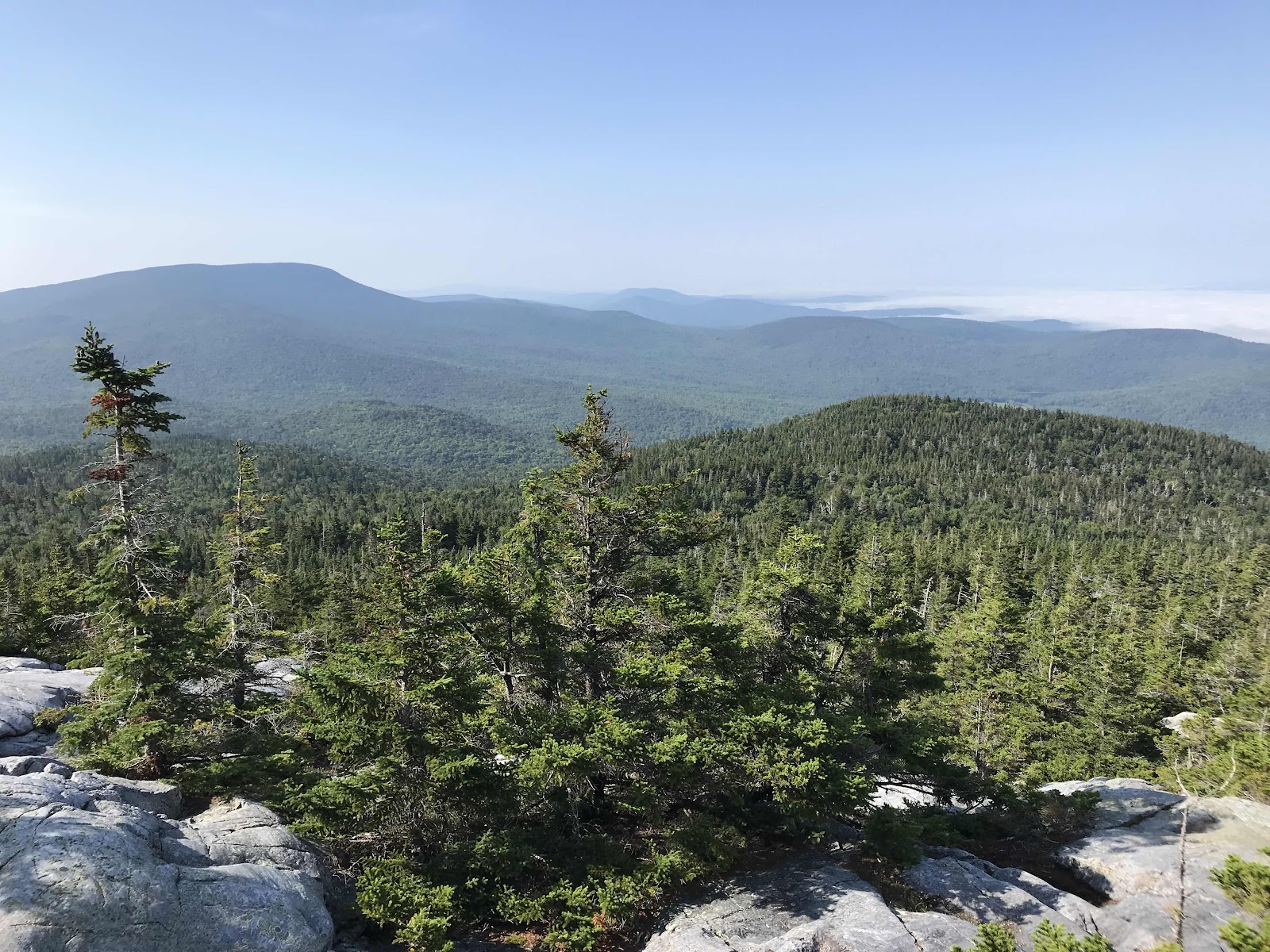
Once we reach the ridgeline, there is a side trail to the North Peak. We head over there and take an extensive breakfast break. It’s 0.3 off the trail. For many hikers, 0.2 is the limit for any side trails and for many more they may not even be willing to do that! Needless to say, no other hikers show up. It’s a great open view with expansive quartz ledges that are big enough for many people to camp on. We should have come up last night, the sunset, stars and sunrise would have been amazing! The rocks themselves are cool, but then there’s a view too! The view is a bit backlit and steamy looking in the low angle morning sun, but we can see all of the mountains and valleys to the north from which we have come.
After the north peak the trail take us right over the main peak which had better views to the south, but none to the north. We can also once again see the cloud bank over the Connecticut River valley, but no actual view of the river. I bet it’s a neat sight when it’s clear!
On our way down the mountain we visit the Hexacuba Shelter, a neat hexagon shaped shelter. It’s 0.2 off the trail and up a hill, so it’s a long way to go for a break, but we figure it will be neat, and it is. No one else shows up, and judging by the log book and the number of hikers we’ve seen so far today, there may have only been one hiker here last night. This is where we had wanted to make it to last night, but we were worried there’d be a big NOBO party here and the shelter would be full and the two slanted tent sites too! We played it safe staying at Brackett Brook. It took us about 3 hours to get here today, so we would have been arriving at last light if we came last night, so it’s probably for the best that we didn’t push for it. All of the shelters and campsites have been down side trails ever since we began seeing AMC staffed sites, just before we left Maine. Now we are in an area maintained by the DOC, Dartmouth Outdoor Center, and they also put all the shelters down side trails.
We have another long drawn out break at the shelter and eat another meal. We then continue down the mountain to Jacob’s Brook at the bottom of the valley. There’s a road down there and we learn from Guthook that if we walk 0.1 down the road to the right, we’ll come upon a fine swimming hole. We are tired and it’s too hot today, so we gladly leave the trail for the very worthy swimming hole! At it’s deepest, the swimming hole is deeper than I am tall! Guthook allows us to click on icons for each upcoming point of interest and read reviews about it from other users. We know where every road, powerline, view, water source, campsite etc is and we can see pictures of each place and read others comments about it! It’s pretty crazy.
After swimming we have another climb, up Smarts Mountain. It isn’t steep but the heat and humidity make us feel worn out. At the top, there is an old fire wardens cabin that now serves as an AT shelter, and there is also a really nice tower which we are free to climb up. It is mobbed by NOBOs. We saw so many NOBOs on the way up, at least 20 and there seem to be 20 more in and around the tower and shelter. It feels like we have to weave through them to reach the tower stairs. Being shy and introverted like I am, I never like approaching large groups. There’s a bunch of them sitting on the floor in the top of the tower smoking weed too! You can’t even see the view while seated, so they are essentially wasting the space for no reason and preventing others, like us, from enjoying it. We don’t stay long or really get to enjoy it. AT hikers are supposed to follow a basic common sense code of ethics, with one of the guidelines being share the view! These people certainly weren’t doing that!
On the way down the mountain, a girl going up asks us if it was busy up there. It turns out she has been trying to let the the big group get ahead so she could have some solitude again. She tells us the AT isn’t like this every day, that they all just got bunched up back in Hanover, when several days worth of hikers got off trail during the possibility of tropical storms. That is very unfortunate, and I feel bad for her. We continue to see more hikers going up as we descend.
We had high hopes of making it 15 miles today to the next shelter. But the heat sapped our energy and side trails, views and rest areas slowed us down as well. We make it 11.6 miles down the trail plus 1.2 miles of side trails. That’s a pretty good total for us. We camp near a view ledge on the way down Smarts Mountain. We get to have dinner with a view and space for just us at a single tent site. We really enjoy sleeping away from everyone else for the least possible chance of sleep disturbance.

Breakfast on a view ledge on Mt Cube’s North Peak
View of Connecticut River valley from Mt Cube. Once again the valley is fogged in.

Summit post

Looking at the terrain ahead from Mt Cube. We are looking at Smarts Mountain and the valley we must cross to get to it.

Hexacuba Shelter, it’s a neat one! Would have been cool to make it here last night.

Swimming hole on Jacob’s Brook, it was 0.1 miles down a dirt road from the trail. Well worth the side trip.

View back to the North from Smarts Mountain fire tower. Mt Cube is the one on the left.

Smarts Mountain fire tower

View back to Smarts Mountain from view ledges on the lower ridge

View to the East at sunset from the view ledges

Dinner with a view for once!
Day 47
Thursday August 26th
Dowd’s Country Inn, Lyme NH
421.8 - 428.2 = 6.4
It’s easy walking the rest of the way down the Smarts Mountain ridge in the morning, then we have one more small unnamed mountain to go up and over. At the top is Holt’s Ledge which would we a nice place to sit, but it’s fenced off for falcon nesting. This is supposed to be a popular day hiking area, but we see no one. We cross a series of 3 roads through the morning and aren’t far by road from Hanover so you’d think there might be people out hiking.
We made the decision this morning to escape the heat wave and make a detour to town early. The little town of Lyme is accessible from all 3 of the roads we cross, but we go to the furthest one, Goose Pond Road and get picked up and whisked away to the Dowd’s Country Inn.
We set our pick up for noon and we have to do a bit of cruising the last hour to make it. For us, cruising is probably what a normal pace is for other hikers. To us this fast pace looks like speed walking and not fun and sustainable. We do find it fun in short spurts though, especially when we know the end is near. We have a relatively pleasant time going the 6.4 miles required of us today, except for one nuisance the stupid eye flies! Little gnats that like to come and land in your eyes!! Apparently they feed on lacrymal secretions, which is a fancy word for tears!
A man in a nice big air conditioned truck comes to get us. We assume he is one of the owners. He tells us there were 18 hikers at the Inn on Sunday night, waiting out the tropical storm that never was. No wonder we saw a big bubble of hikers! We are glad we weren’t here. Now is just us and one other hiker, an older lady named Solitaire that we keep running into.
The inn is a historic b&b dating back to the 1780s and it’s located in the little town of Lyme with many beautiful old houses. There’s a general store next door and an Italian restaurant. The Inn also house it’s own restaurant, the Latham House Tavern. They are supposed to be open Thursday through Sunday but they are understaffed, so they are not opening tonight, even though it is Thursday. We visit the general store and get potato salad, veggies wraps, bananas and juice plus some additional snacks to take back to the trail tomorrow. Then we sit in our air conditioned room while they do our laundry.
The heat wave is supposed to be over by morning. we will go back to trail after breakfast. We have only 12 miles to go to reach the campsite on the edge of Hanover. Just before bed there is thunder and lighting and rain, a good sign that the weather is shifting.

Nice forest in the morning

View from Holt’s Ledge, back to Smarts Mountain

Mmm pistachio butter from the hiker box! That’s a $15 jar of nut butter!

A beaver pond. You can see on the trees across the pond that some of the leaves are already starting to change color!

They have a surprisingly diverse selection inside this little store, but it was expensive!

View down the main road near the general store

This is what $30 will get you at the general store!

What a beautiful old inn! So glad we visited!

Our comfortable little room upstairs!
Day 48
Friday August 27th
Velvet Rocks Shelter
428.2 - 440.7 = 12.5 miles
We go back to the trail at 10. We immediately begin a climb, but it’s much cooler today, so it doesn’t feel unpleasant. We have soft footing and a reasonable grade as we head up Moose Mountain. There are two peaks on the same ridge. On the ridge between the two high points is the Moose Mountain shelter. It’s down a side trail that we would normally skip, but our Guthook guide says it has a neat privy with only a roof and no walls. It has walls when we get there and looks brand new, so perhaps it was under construction at the time of previous inspection.
There is no view from the north peak, just forest. We do get a view from the south peak though. It’s nothing special, but we stop there for lunch anyway.
Once we get down off the mountain we are just walking over gently rolling hills all afternoon. We are parallel to the Connecticut River and have been for days. This area was once totally deforested and completely farmed out. We see evidence of this in the old stone walls we’ve been seeing in the forest for days. The forest that has grown back is quite nice with a surprising number of big old trees.
With 4 miles to go we pass what might be our last water for the night. We aren’t sure if there will be water at our campsite tonight or not, it might be dry. We will need to carry extra for drinking, so we decide to cook dinner at the water source, rather than have to carry water for cooking too. We eat much earlier than usual at about 4:30. We eat a mystery meal that I acquired from the hiker box at the Barn Door hostel. It’s some kind of homemade dehydrated meal. We also saw meals from the same person at the hostel in Gorham, but they were sadly among the food I put back at the last minute in order to reduce any extra and unnecessary weight. This meal turns out to be amazing, one of the best backpacking meals we’ve ever had. The only thing we had been able to identify before cooking it was beans and pasta. We are pleasantly surprised to find out that it’s a delicious thick and hearty tomato sauce with beans, leafy greens and whole grain pasta!
All afternoon the terrain is so easy that it feels like we’re out for a leisurely stroll. We make good time, and easily make the 12.5 miles to our planned destination. We check out the water just before we get there and it is definitely collectable, but it isn’t the best source. It reminds us of the springs in boxes in Maine, only this time the water is pooled inside of a length of culvert tubing and covered with boards to keep animals from getting in and drowning. We set up camp near the Velvet Rocks Shelter. We manage to find a spot to ourselves on the side trail to the shelter but still a good tenth of a mile away where we know it will be quiet. We hear there’s another big bubble of hikers coming, this time it’s the ones that were all stuck in Rutland, Vermont during the storm. Rutland will be our first resupply town in Vermont.
We are less than a mile from Hanover and will get to walk through town tomorrow. We are so excited to go out for breakfast! And I am excited for the health food store!
Partial view in the morning, on the way up Moose Mountain
Forested Moose Mountain. It’s always nice to see a sign at the top, view or not!
Fun DOC signs for the Moose Mountain shelter
Lunch time view
A nice flower filled meadow that the trail goes through
Mystery meal packs. We ate the one on the right.
And this is what it turned into! Yum!
One of many stone walls in the forest.
Another stone wall
Our first marsh
At the top of another mountain but you can’t tell! This is called Velvet Rocks.
Fern filled valley near the water source for Velvet Rocks shelter.


Comments
Post a Comment