09/05 - 09/09 Rutland to Bennington
Day 57
Sunday September 5th
Homer Stone Brook
506.8 - 517.9 = 11.1
We have our final free hiker breakfast at the Yellow Deli. There are leftover banana breads and sweet potato cake that they must be trying to use up from the leftovers in the deli. We are also given brown rice and scrambled eggs. I have been enjoying the warm rice for breakfast. We also get our hot mugs of maté. We’re gonna miss not having a dispenser full of maté available to us every day!
Before we can go back to the trail we need to get cash from the ATM to leave a donation. We have no idea what an acceptable donation is. We’ve stayed 4 nights and gotten 4 breakfasts. We did some “work for stay” by picking chamomile and herbs in the garden and by working a day on the farm, but they gave us free dinner in the deli for both of those. In the end Jeff decides on $40, but I feel like it should be more. I wonder what the average hiker leaves and also wonder how many leave nothing at all. They really were wonderful people and it was such a peaceful and restful place to stay.
We schedule a shuttle with a lady named Flipakey. She was never a hiker so we are not sure why she has a trail name. We do not ask. Speaking of trail names, we tried ours out for a few days and I couldn’t stand it. We went right back to being Jeff and April. Some people just can’t believe it when we tell them we don’t have trail names yet. We spend most days alone, so we aren’t gonna get any trail names unless we name ourselves. We can’t figure out any names we’d like to be called continuously and have to hear all the time and talk about.
Flipakey says she just likes people and that is why she shuttles. She is really nice and we are grateful for her service. There is a way to take the bus back to the trail, but it doesn’t run on Sunday. Her little toy poodle rides with us and he’s pretty cute. The has long soft fur that is dark brown and wavy and looks exactly like a plush stuffed animal, like a teddy bear! He mostly rides on Jeff’s lap but visits me in the backseat a couple times. She is a life coach and the dog is apparently a therapy dog!
We are hiking by 10. We are mostly in the forest all day, with just a few partial views. We go up and over one little mountain and start on another. We get a light drizzle in the afternoon and then we go into a cloud. It doesn’t really matter since there aren’t any views out of the forest anyway, but it does make the forest darker and gloomier. We make it just over 11 miles, stopping just short of a popular campsite and shelter. It’s so popular that it has a caretaker and a fee is charged to make sure the area is well looked after. Now that we are out of New Hampshire the caretakers of the trail are the GMC or Green Mountain Club. We know that Peter and Kae and the early risers are all camped there and we’d prefer to keep our little bit of separation, so we are happy with our slightly shorter day.
Our backpacks are pretty stuffed full of food. We collected quite a bit between the hikers boxes at the Inn at Long Trail and the Yellow Deli, plus there is always the excitement of shopping and buying more. We are curious to see how far it will takes us. The next town, Manchester Center, is only 2 1/2 days away, so we can definitely skip that one. It is both good and bad to skip town, on the one hand it’s time consuming trying to get a ride there and back and to shop, but it’s always also nice to get fresh food or a restaurant meal.

Clarendon Gorge

Bridge over Clarendon Gorge. Me with my overstuffed backpack. It’s about a foot taller than I’d prefer!

Airport lookout

Minerva Hinchey Shelter. We stopped for lunch. Nice big shelter with a picnic table inside.

A partial view across to the White Rocks State Recreation Area from the Domed Rock.

I really enjoy these large rocks with ferns on them. We’ve been seeing them since day one. They are like rocks pets and the ferns are their hair.

Rock garden at the White Rocks junction. There used to be two of these but the other one was knocked over. They look kind of neat, but it’s not Leave No Trace and doesn’t really belong in the forest.

Found these at TJ Maxx. They are REALLY good! They are like Bobo’s Oat Bars, very similar ingredients
Day 58
Monday September 6th
to Mad Tom Notch Road
517.9 - 533.6 = 15.7
We run into Peter and Kae in the morning. They were a mile and a half further on than us, but got a later start. We hike with them for a little while and then they continue on when we stop for our first break. We prefer to hike alone anyway and they also hike too fast for me. Our first stop is alongside the Big Branch River in the Big Branch Wilderness. An extended rest along a beautiful stream is always nice.
We go over one mountain and get rain just before the summit. We retreat to the woods and take lunch under our umbrellas. It’s not great but we stay dry enough. We continue over the summit during a break in the rain. It’s not much of a mountain, with barely a view from the bare rocks on top, but we can see down to the highway 7 valley, a road we parallel for a long while through Vermont.
A second wave of storm rolls in and it pours for a good half hour, it slows us down a bit as we attempt to avoid puddles, but we stay dry under our umbrellas. We take a dinner break at the Peru Peak shelter, then continue on, entering Peru Peak wilderness. Peru Peak is a forested peak, but the forest in nice and Styles Peak just after it has a little view. We thought we might camp up on the mountain but we still have a little daylight and energy and we keep going to a forest service road just below the next climb up Bromley Peak. It would have been neat to keep going up Bromley Peak because it’s a ski area, and they leave the hut at the top open for hikers to camp in. We run out of daylight though. We have a good quiet camp spot by ourselves and there’s no traffic on the road.

Little Rock Pond, GMC fee site for camping at the shelter.

The Big Branch Wilderness of the Green Mountain National Forest. Wilderness has the highest level of protection of any federal wild land.

Breakfast along the Big Branch. Bridge is the trail.

View of the Big Branch from the bridge. There were many trees growing on the rocks with their roots visible, like this birch tree.

A view opening on Baker Peak, 2,771 feet.

Looking down into highway 7 valley from Baker Peak. Across the valley is the Taconic Range of mountains in New York. We are near New York for a long time before the trail goes into it.

Neat lines of rocks leading back up to Baker Peak. It makes for tricky footing, so there is the bad weather bypass trail to the right.

We walked on about 1/4 mile of board walks here, just before the Peru Peak Shelter. We were saved from a bit of bogginess.

The wilderness of the fine birch trees!

View from Styles Peak, 3,375 feet
Day 59
Tuesday September 7th
Stratton Mountain
533.6 - 554.3 = 20.7
Before bed last night, we made the decision to wake up early and try to catch the sunrise on the mountain top. When the alarm goes off at 4:30, it’s very tempting to turn it off and go back to sleep. Somehow we manage to get up and get walking by 5:15. We see the glow of the sun on the horizon, but the forest is still very dark and we need our headlamps. I don’t actually have a headlamp. I use a solar Luci lantern. I have to hold it in my hand, but I like it because it doesn’t need batteries, just the sun.
We should have just slept in, because we quickly climb into a cloud bank and miss the sunrise completely. We stop in the hut at the top to make breakfast and hope it will burn off by the time we leave but it doesn’t. It’s supposed to be a nice sunny day.
We know that it will clear out eventually, but we don’t have all day to just sit around and wait. We’re full time hikers and must keep moving. By 9 AM, we are across the highway that leads to Manchester center, VT routes 11/30. As we expected, we go across and keep on walking. From there we hike along a forested ridge above town. The hitch to town would have been 5 miles and it’s for the next 5 miles that we can see town at a few different view points.
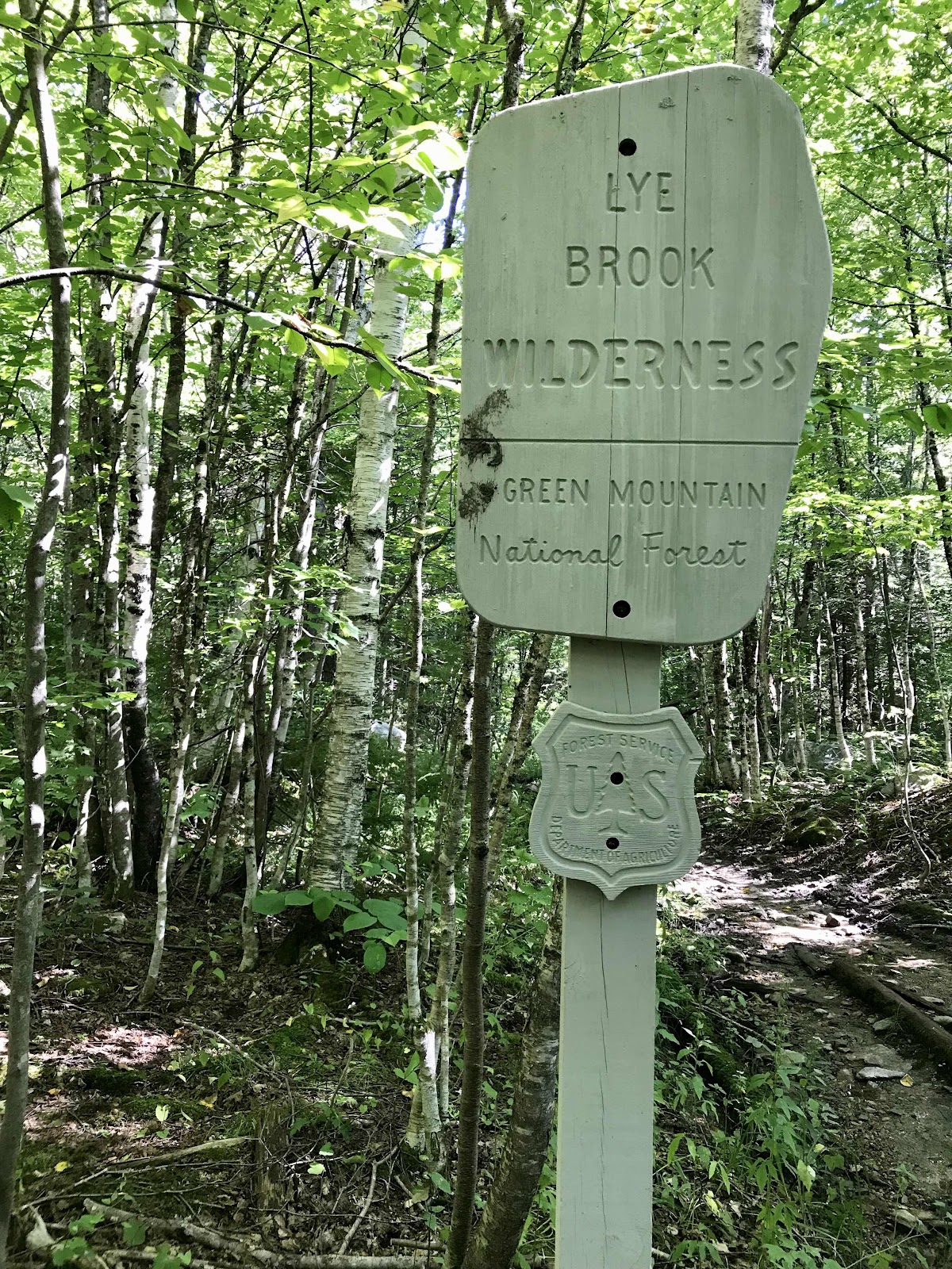
In the afternoon we enter Lye Brook wilderness. Peter and Kae catch up to us at a creek crossing. They were further ahead of us last night and went to town for a few hours this morning. We hurry on ahead though and don’t see them again. The trail gets really muddy here for the next 4 or so miles as we pass through this section of wilderness. We’ve been hearing from the NOBOs that the trail is muddy in Vermont. That is all they say about Vermont, but so far it hasn’t been bad. We wondered if they were just being dramatic about it. NOBOs and SOBOs have different perspectives, so we’ve always followed the mantra “never trust a NOBO.” It is rather muddy today though but we’re feeling good and race through it pole vaulting around it and skirting the edges of the muck. We use our trekking poles as probes for poking at the muck and finding solid footing. We pass the next shelter and use our burst of mysterious energy to make it up one final climb for the day, Stratton Mountain, another ski area. We make it to the top just minutes before sunset and get to see an amazing view from the fire tower at the peak.
We didn’t want to get another foggy morning and miss out on the view, so we’re really glad to have made it.
Without the tower, it would be just another forested summit. From the top there’s a side trail that goes along the ridge line to the ski area, but sadly it’s scenic gondola ride is only on the weekends and we’ve missed it. There’s no where to camp and the only thing we can do is keep going. It gets dark quick and it’s hard to see any flat spots in the forest suitable for camping. We know there will be at least one “stealth” camping spot, but the first one we were aiming for is surprisingly full of tents! After about a mile Jeff somehow manages to find us another spot. In the meantime, it gets really dark and we’re really tired and I kick a stump in the trail that I couldn’t see. My toe starts bleeding like crazy. Blood pools is my sandal and gets gross and sticky, but we keep going.
I am so relieved when we can finally stop. It’s only 8:15, but feels like midnight for how dark it is! We clean my wound with Dr Bronners soap and our water squirt bottle and bandage it up. This is our first bad aid usage of the trip! It turns out to just be a surface scrape, which is great, but it sure bled an alarming amount!
We decide it’s too late for dinner and just set up the tent and get to bed. Now we know what we can accomplish with a full day on the trail. We did over 20 miles, and I don’t suspect we’ll have a burst of energy like that again anytime soon!

In the clouds on Bromley Mountain, 3,263 feet. We’ll come back and hike the Long Trail one day and sleep in the hut and see the sunrise and sunset!

Bromley Mountain warming hut.

The trail goes down a ski run

Spruce Peak view. Not really a peak though, just a rock with a view down to Manchester Center.

Spruce Peak shelter. This was a nice one, fully enclosed with a sliding front door!

Another view of Manchester Center from Prospect Rock
The buggiest of the wildernesses!

Mud to maneuver around. We usually stick to the edges and have to crash through the bushes that grow there.

A short break from the muck with some nice tall trees. The forests of tall trees seem to always have the best trail.

A nice section with lots of leaf cover on the ground

Sunset on Stratton Mountain 3,940 feet.

View North along the ridgeline to the ski area. You can just make out some infrastructure poking out of the forest on the rounded park of the mountain.

View South

View East

View West

View of the tower

Informational sign at the base
Day 60
Wednesday September 8th
to Goddard Shelter
554.3 - 569.1 = 14.8
We wake up at 5 and I think we should get up and go but Jeff wants to go back to sleep, so we sleep until 6:15. The early risers come past while we’re packing up. They were the ones occupying the first tent site we wanted! Dr Dolittle says a bear visited their camp in the night, so we are glad that ended up where we did! The bear caused no harm but huffed and puffed and sniffed around and that would sure make it hard to fall back asleep!
We hike down the mountain and across two forest service roads. There is a lot of bog muck in the lowlands. We are tired and dragging for much of the afternoon, as we expected. The forest it a thick and monotonous jungle. For hours we stare at our feet as we maneuver the bogs. Luckily it gets easier in the afternoon as we do our final climb and it dries out a bit and we get our second wind.
The final climb of the day takes us up Glastonbury Peak to another fire tower with a great view. The summit would be viewless without the tower as its thickly forested with tall spruce and fir. There’s nice camping around the base of the tower, but there is heavy rain in the forecast, which compels us to head for a shelter. We make it to Goddard Shelter by 5:45 which is so nice since we’ve hiked late the last 3 nights. The Queen of Denmark is here but Dr Dolittle and Top Shelf went further.
We get space in the shelter as we have been hoping for all day. We are surprised that it’s not full. There ends up being just 5 of us in the rather spacious shelter. We are camped with two Long Trail Hikers and one older guy who is doing a long AT section hike. Right as it get dark thunder and lighting begins and rain pours. We can’t believe how much it pours. The forecast was calling for 1-2” and I think we are going to get it for once! We are so glad to be inside the shelter.

This is how we should be hanging our food every night. It’s nearly impossible to find the tree with the correct specifications. There have been bear proof food lockers at most of the campsites recently.

A very well constructed beaver dam. How do they stop the water, we wonder!? We always stop marvel at these constructions.

Really water laden muck

Leaves come in handy for making a water collection spout. Jeff has rigged one up here, you can see it just below our water bag in the photo.

Glastenbury fire tower

View from the tower

Westerly view from the tower

Looking back toward Stratton Mountain and Bromley Mountain

You can see how thick the forest is in this photo and definitely wouldn’t allow for any viewing without the tower.

Inside the forest at the base of the tower
Day 61
Thursday September 9th
To Bennington
569.1 - 579.2 = 10.1
It rained all night, creating white noise for a pretty peaceful nights rest. We are not disturbed by any of the other shelter dwellers. It’s the best nights sleep we have had in a shelter yet, and for this we are very grateful.
We have swampy trail with creeks running down it today from all the rain. It’s only 10 miles to the next highway though and it doesn’t take very long. We make a reservation at the Catamount Motel in Bennington and by 2 PM we are at the trailhead waiting for our ride.
The motel is a fine motor inn, our favorite kind of hotel accommodations and it’s just a short walk outside of downtown. They have a box of loaner clothes in the office that are actually hiker size and look like clothes that young people like ourselves might actually wear. We take showers put on our loaner clothes and become anonymous citizens. For the rest of the afternoon we are no longer hikers, just regular tourists.
We have a late lunch at the Avocado Pit, where we get massive burrito bowls with rice, beans, corn, mushrooms, avocado, lettuce and salsa. It’s one of the best bowls we have ever had, and perhaps the largest too. We are quite pleased.
Bennington is a big town with plentiful civilization and retail, but most of it is a mile or two outside of the historic downtown strip. We don’t want to walk that far, so we settle for Dollar General which is oddly in downtown. They haven’t had a delivery in a month, so the store looks totally ransacked. We manage to piece together a meal to take back to our hotel room though. We were really excited to use our microwave, but the best we can do is frozen broccoli and we get a can of baked beans and a bag of frozen strawberries to go with it. It’s not the most exciting meal, but it’s pretty healthy and will fill us up. There was a health food store nearby too, but it closed early and we didn’t make it in time. We had about a days worth of food leftover in our backpacks, which means we carried about 6 days worth from Rutland! We don’t need to buy any more hiker food to get us the 18 miles to the next road. After eating and shopping, we retreat to our hotel room for the rest of the afternoon.

Two individuals still sleeping in the morning

Glastenbury Wilderness, another mucky section of trail coming up!

Extra wet from the rain

Our only view down the Bennington, thanks to the power lines.

The trail goes through split rock

Looking back at split rock

Holy smokes! Massive double birch burls!

Someone left trail magic beer near the trailhead. Jeff is delighted. He gets to have my beer too.

High water in the river by the highway. On the map it’s marked at City Stream. We had lots of dark tannin rich water on this leg. The hemlock, spruce and fir trees stain it with their needles. It’s like conifer tea!


Comments
Post a Comment