07/30 - 08/02 Carrabasset Valley to Rangeley
Day 20
Friday 07/30
to S. Branch Carrabasset River
188.2 - 196.6 = 8.4
It rained a lot yesterday afternoon and through the evening. We are expecting a rainy depressing morning in which we lack the motivation to leave the hostel, but we are pleasant surprised that the storm seems to have passed through and it’s just low foggy clouds remaining.
We get a continental breakfast included in our stay. Jeff and I get lucky to be some of the first ones to check out the selection and snag the only 2 peaches and also the only 2 ripe bananas. There is also cantaloupe and an assortment of cereals, muffins, bagels, English muffins, orange juice, coffee and tea. They actually have oat milk, so I get to have a delicious bowl of chocolate granola along with my fruit, coffee, earl grey tea, orange juice and muffin. It’s a much healthier breakfast than the Sterling Inn and leaves me feeling great!
During breakfast, I find out that we can slack pack the first 8 miles of the days hike for only $15 for all 4 of us. This means that they will deliver our packs to a road crossing that is 8+ miles into our day, but is an easy drive for them. We get to day hike with a small pack, which they provide and just carry snacks, lunch, water and a warm layer. It’s an incredible deal that’s too good to pass up. It’s also a bonus that we’ll be going up and over a mountain and won’t have to strain to get our heavy packs full of food up and down. We are beginning another 3 day stretch and having the first day easy will be so nice.
I had a wool shirt delivered to the hostel that luckily arrived yesterday and I also got a new sport bra and traded my shorts for a different pair from the loaner clothes. I leave the hostel in a complete new set of clothes.
We haven’t seen Jay in days and thought we’d never catch him again, but he was at the hostel too, and hikes out with us. He has opted not to do the slack pack, because he doesn’t want to rearrange his pack. He’s got some solid leg muscles and keeps pace with us slack packers most of the way up the climb. He eventually out paces us near the top and we don’t see him again.
The climb is easy and fine. We are climbing the Crockers today, up two peaks, North and South Crocker. The first peak doesn’t have much of a view. The second one has a bit of a view. It’s pretty with the low clouds, but it’s windy and chilly. For the first time it’s cool enough for me to hike with my fleece pullover on, but I still wear my shorts and sandals. We have plentiful food and snacks for the hike, including a peanut butter banana and avocado pita sandwich. It sounds like a weird combo, but that’s one of our favorite quick meals for hikes and road trips and lunch at work.
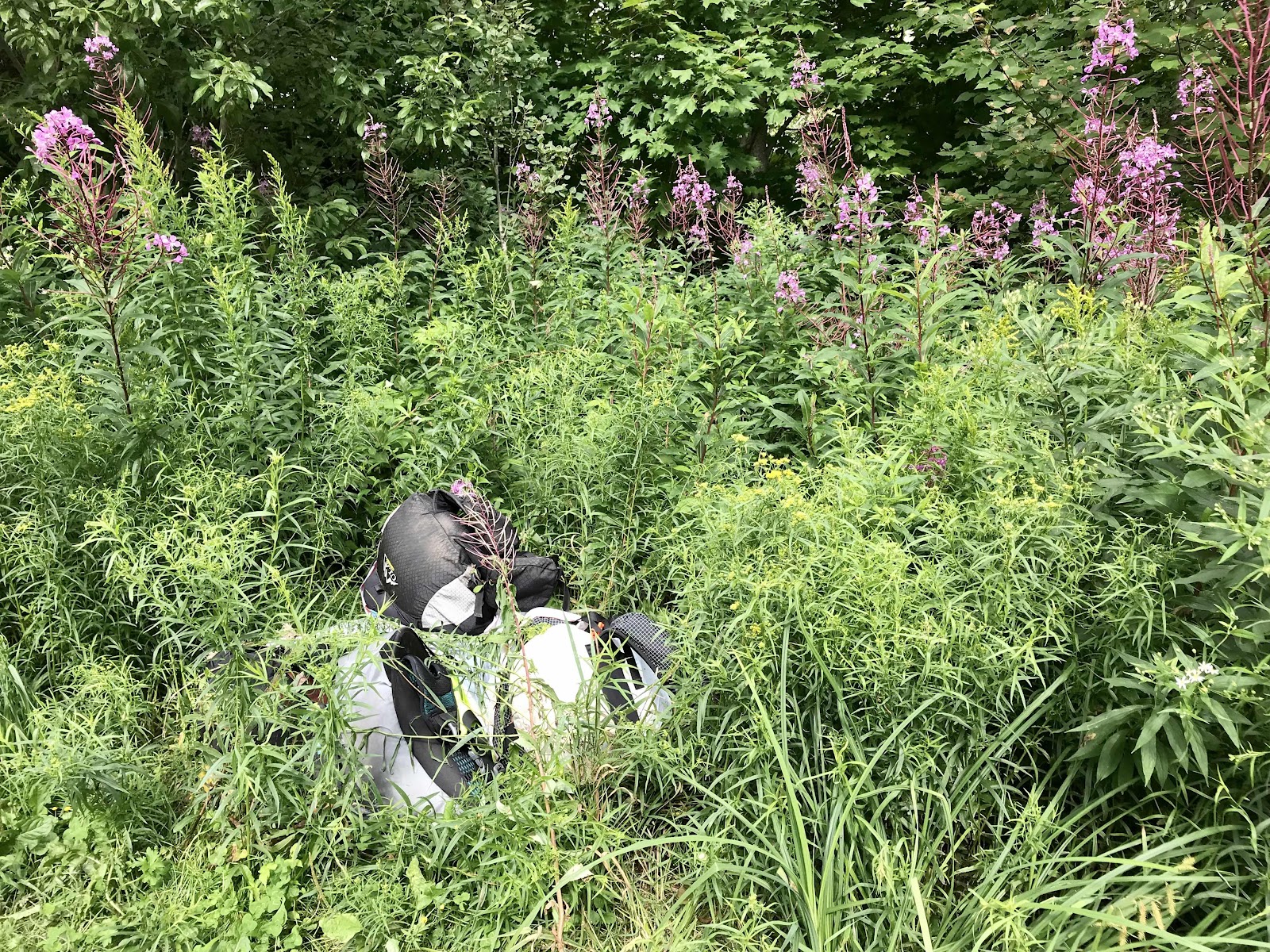
We are down the other side at at the road where we pick up our packs after only about 5 hours, including breaks. We feel so great from having been unburdened all day, that’s it’s almost as good as taking another day off. We have to walk 1/2 a mile down a logging road to where there is a gate and parking lot on the other side. We had been told to expect to look for our packs hidden in the trees, but they are just right at the edge of the gravel lot, in front of some cars and smashing a bunch of fireweed plants. They look as if they’ve just been chucked out of the car into a haphazard pile. It’s pretty funny! I guess we got what we paid for. We thought it sure seemed cheap for all the work involved in loading our packs into a car, driving them out here and then hiding them. They are also wrapped in trash bags in case it rained, which makes it really hard to lift them, so we definitely don’t blame the guy. We are also thankful that no critters got in them. It is always our worst nightmare to have rodents chew through our packs while they are unattended.
From the parking lot, it’s just over 1/2 a mile back to the trail and down to the South Branch of the Carrabasset River, where we stop nice and early and camp for the night. There is another climb after this, and we’re not about to start it in the late afternoon.
We have caught up to the the group of hikers that starts at the crack of dawn and finishes super early and gets in their tent immediately after dinner. They stayed at a different hostel last night and now they are back on our same schedule and we will probably spend the next 3 days being last to camp. The 4 of us each manage to get a space for our tents and one more hiker shows up after we do. In total there are at least 8 tents tucked into the woods around us.
One hiker is called the Queen of Denmark. She is an older lady from Denmark and had to come to the US via Costa Rica or Mexico. Apparently those are the only two countries you can enter the US from right now? So she went on a two week tropical vacation, came to the AT and gets to stay 90 before she has to go back for another two week tropical vacation and be allowed in for a final 90 days and finish her through hike. She is hiking with Dr Dolittle, and he is an older man who has recently retired from a 31 year career with Proctor and Gamble. We hiked with him for a little while before we picked up our packs, and he was a really interesting guy. He was a chemist that worked on various formulations of laundry soaps and other products for Proctor and Gamble. He’s also been very active all his life and has been backpacking to all of our bucket list destinations in Alaska. He has an amazing retirement home near the Red River Gorge in Kentucky that we promptly tell him we will one day come visit. He got the name Dr Dolittle because he saw so much wildlife in the 100 mile wilderness, bears, moose, minks, rare birds, etc.
We get to have a luxury dinner tonight, since we didn’t have to pack it over the mountain. We eat canned potatoes with mustard, which I drained and put in a Ziploc before we left. We also have two pouches of soup made by a local company that were available for sale in the freezer at the hostel. One is veggie and bean chili and the other is peanut coconut curry quinoa. We eat them with Triscuits and I wilt in some fireweed leaves for extra greenery. It’s a fantastic meal. Tonight we get to be the ones in our tent by 6:30. Feels great to have so much time for resting before bed. We go to bed happy, full and well rested. Ready to tackle the Sugarloaf Mountain tomorrow.
Partial view from South Crocker of Sugarloaf (peak on the left) and the ridgeline extending out to the right. We will be climbing Sugarloaf and walking that ridgeline tomorrow
Really cool mushrooms near the top. We’ve never seen purple ones before!
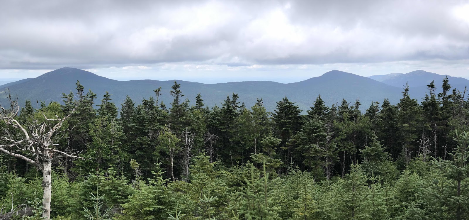
View of the Bigelows
Our back packs dumped in the fireweed patch
Luxury dinner: locally made bagged soups with triscuits. I foraged some fireweed greens for extra nutrition.


Day 21
Saturday July 31st
To Sluice Brook Logging Road
196.6 - 206.9 = 10.3
We begin climbing first thing in the morning. We are back to walking with our heavy packs. Heavy is relative though, as it varies depending on the hiker and how many luxuries they carry and how much food they eat. Ours are fairly light because we share a lot of gear that solo hikers have to carry all of themselves.
It’s about 2 miles of up with about a mile of really steep annoying rock climbing and then we are on the shoulder of Sugarloaf Mountain. I thought we’d be out of the trees up here, but it takes going several tenths of a mile up a side trail to the peak to get out of the trees. In total the side trail is 0.5 mile each way, which really isn’t far at all, but to most thru hikers, and especially the NOBOs, it’s out of the question. It makes me wonder why some of the thru hikers are out here any all.
We have a good view of the ridgeline of the Bigelows from the top at 4,237 ft up. We can also see the summit buildings of the ski area, the infrastructure built up at the base, as well as a few of the runs and lifts. We can see Stratton and Flagstaff Lake behind it and the Carrabasset Valley too. It’s cool, cloudy and windy, but the visibility is good. It’s been pretty cold the last few days, in the 40s at night with the temperatures remaining low well into the morning.
We left camp before Peter and Kay, but they catch up to us at the top. I am surprised to see that they took the side trail. We hike with them back down to the AT and stop at the next lean to for lunch. We have a bit of pleasant forested ridge walking before and after lunch, and then we separate when Jeff and I go off on another side trail.
This side trail is quite a bit longer, it goes up Mt Abraham, another 4,000 ft mountain and is 1.7 miles each way. It’s known for having the second largest alpine zone in the state, behind only Katahdin. It’s very hard for me to get so close to something that neat and just walk past. People tell themselves they will come back, but we are on a very long journey it’s not realistic to come back to so many places!
I’m always the one wanting to do side trails.
I have to convince Jeff but then he always ends up enjoying it. Jeff and Kay and Peter all separately came up with the idea to make my trail name side trail, but I don’t know if I’ll accept it. Trail names seem so silly to me.
When considering side trails you must decide if the joys had today on the side trail will outweigh the possible negative consequences that could result later that day or even tomorrow or the next day. The afternoon became fantastically sunny and it sounds like a great time up there, but what if I don’t make it as far down the AT today as I had planned because I’ve worn myself out on this side trail and then I end up caught in a storm tomorrow in the high elevations of the next mountain? In the end I can’t pass it up. Peter and Kay continue on.
Starting out it’s splendid forested ridge walking among mostly small birch trees and ferns. The trail is super easy and very gently sloped up hill. It feels great walking, truly walking without difficult maneuvers and without the backpack.
We get above the tree line pretty quick and the views are glorious. We can see all the way down to Mt Washington again with pretty puffy clouds all around us. It’s sunny and breezy, perfect hiking weather. There are stacked stone windbreaks at the top and one of them even has a chair built into it. We also get a view of Kingfield, the next town down the road from Hostel of Maine and the place where our takeout burritos came from.
The walk back is nice and then once back on the AT the trail continues to be pleasant. There are no difficult descents off rock cliffs, just very average downhill hiking on soft leaf little in the forest that glowing green in the afternoon light. Most of the way it’s a mix of birch and maple trees, but we see one section that for a little while is purely maples. It must be gorgeous when the leaves change in the fall.
While meandering through the forest, Jeff somehow spots a pine marten in a tree. We stop to watch it for a while. It’s so cute with its little round ears, it looks just like a baby bear!
We stand there long enough to learn that the pine marten is in a very specific tree, the tree of a squirrel! We see the squirrel come home and a chase ensues. Somehow the squirrel wins and succeeds evicting the weasel from it’s home. What a show!
Our descent from the ridge is about 4 miles. For the last mile we walk along Sluice Brook, our water source for the night. We quickly find out why it is called that, when we see it running through a narrow trough that looks just like a sluice! We camp on a old logging road where Sluice Brook crosses it. Peter and Kay are here but the rest of the group has thankfully pushed on. We have made it only 10.4 miles from our previous nights camp, but this is what we had planned for all along, whether we took side trails or not. That means the side trails we worth it and won’t cause us any negative consequences. It’s a highlight of the trip kind of a day. Tomorrow when we go up into the Saddlebacks, it may be similar in the 2nd largest in the alpine in the state, but we don’t mind going again. If I had to pick I’d probably say the alpine is my favorite environment.
Panorama from Sugarloaf with the ski area base below
Ski run on Sugarloaf
View of Mt Abraham from Sugarloaf
Past the 200 mile marker
CCC completion plaque for the AT
Getting above the tree line on the Mt Abraham side trail
View of the Saddlebacks on the right and way down to Mt Washington
Cool alpine trees on Mt Abraham
Close of view of the Saddleback ridge that we will hike along tomorrow.
Rocks and lichens near the top.
Summit Marker 4,049 feet
A lesser summit with rock cairn towers
View of the town of Kingfield from the top


Day 22:
Sunday, August 1st
Piazza Rock Lean-To
206.9 - 218.6 = 11.7
We have a big climb up the Saddlebacks today. At points we are climbing up walls of rock and our pace slows to a mile an hour. We expected this though, and got up earlier than we normally do. We were walking by 7 today. Two hours we reach Poplar Ridge and the grade levels off for awhile. We stop for second breakfast at the Poplar Ridge Lean-To. This is where the group of early risers ended up last night and we heard from a few NOBOs that the areas surrounding the shelter were wall to wall tents last night. We are so glad we had a glorious side trip, enjoyed a very peaceful campsite and didn’t get stuck with the pack.
From the lean to, it’s another steep mile up to Saddleback Junior, our first summit of the day. There are blueberries at the top, which we stop to enjoy, and we briefly enjoy the view back to yesterday’s mountains. It’s definitely cloudier today, but far less windy and the visibility is great. From the peak we follow the “saddleback” up and down the ridge line to two more peaks, The Horn and Saddleback Mountain. Both the Horn and Saddleback are above 4,000 feet, and for 3 whole miles, we’re above the treeline. We get to spend several hours marveling at another one of the most extensive alpine areas in the state and some of the best views in the state. We enjoy the stunted alpine plants and lots of blueberries. Views include the town of Rangeley and its lakes, the Saddleback Mountain ski area, and endless mountains and clouds. We get a tiny bit of rain, but it barely bothers us and it clears out quickly and we stay dry the rest of the day.
As always, the descent off the mountain drags on a little longer than we’d like, but we make it to camp by 6:00 not feeling particularly worn out. We have plenty of time to lounge around, eat an early dinner and get to bed early. We are only 1.8 miles from the next highway. We have again chosen to save a couple miles for the morning, so we can take an almost zero day without having to pay for two nights lodging. Unfortunately a rowdy group of NOBOs shows up just before bed and howls and cackles loudly in the shelter, annoying us from our tent.


Day 23
Monday August 2nd
To Maine Route 4
218.6 - 220.4 = 1.8
Rain starts some time in the night and it’s still going when we wake up in morning. I lack the motivation to get up and out, but I have to pee so bad I have no choice. I am surprised to see that all the early risers are still here. We caught back up with them, but luckily this campsite is spacious and we weren’t forced to camp in an undesirable spot on a slope or on top of roots. We now see we are in a mud puddle that we didn’t recognize last night and the drippings from the rain fly caused mud to be thrown up onto the inner body of our tent all night and it’s a mess now.
There were 4 people sleeping in the shelter overnight and although they are awake when we are trying to get going in the morning, they don’t make much space for anyone else to get out of the rain. They lounge reclined in their sleeping bags with their air mattresses still deployed. We manage to squeeze in and get our oatmeal cooked. This morning I have the special joy of adding lots of blueberries that I picked up on the mountain top and brought down last night.
It’s never fun to pack up a wet tent while it’s still raining, but it isn’t raining hard, and by the time we’re packed up and ready to go, the rain has ended. It’s just two easy miles to the highway. We have a reservation at the Hiker Hut, which is just down the highway from the trail, so it’s very convenient. We are lucky to get a space, as they don’t have much capacity. There are maybe 3 couples huts and 6 dorm beds and 1 tent site. Peter and Kay also get a space, but the other hikers we keep camping with aren’t as lucky and end up taking a shuttle back to Stratton to get a place to stay. We called 4 days in advance for our reservation. It’s not always easy to know where you will be because it’s hard to know how many miles you will be able to do.
The place is owned by cool older guy named Steve. He shuttles us to town for laundry and eating and picks us up a couple hours later and takes us to the grocery store on the way back. Its probably about 10 miles from the trail to town. It’s a really small touristy town on a big lake with just a few restaurants. We choose the Red Onion for veggie pizza and salad. At the IGA we get lots of fruits and veggies for dinner and breakfast. We sent a box here and I am glad because the IGA is ransacked and they are out of both Clif Bars and Clif Builders Bars!
When we get back I sort food and repack our food bags. We have a nice 3 sided hut along the stream surrounded by woods. It’s very quiet and peaceful. We’re off the grid, so there’s no electricity and no cell phone service or WiFi. We prepare and eat dinner from our hut and go to bed nice and early early. Dinner is a large fruit salad, a large green salad, hummus and tofurkey sandwiches and cookies.
Our stream side hut

View of Rangeley Lake from the community center in town
Our restaurant
A view of the downtown strip


A look into our hut
A look up the creek from our hut
Fantastic solar and propane heated shower creekside
The main buildings of the lodge. Bunkhouse for 6 on the right, little store in the center and owners hut on the left. There were 3 other huts and one tarp covered tentsite and that was it. It’s a small place.


Comments
Post a Comment